At the end of last week, owners of the land-locked properties in Undercliff Drive received a letter from Bill Murphy, Head of Contract Management at Isle of Wight council.
The letter (embedded below) – which has been followed up with a press release today – stated that council officers had been working with Island Roads to develop a plan to provide a “low cost limited access road” from the west and pedestrian access from the east, as agreed at the November 2014 Executive meeting.
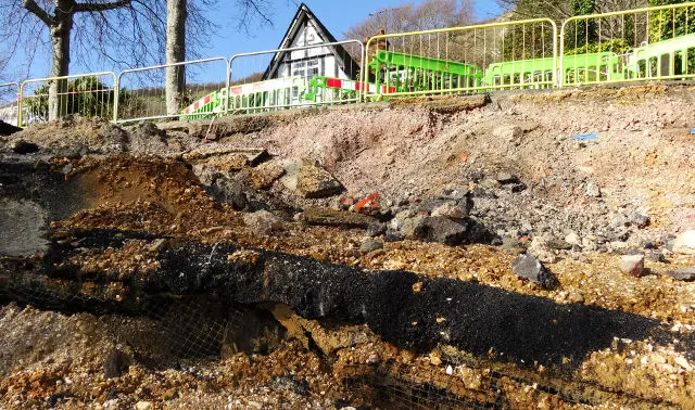
The Executive had agreed to put aside up to £500,000 for the work following a major landslip in early 2014.
Letter and plans contradict each other
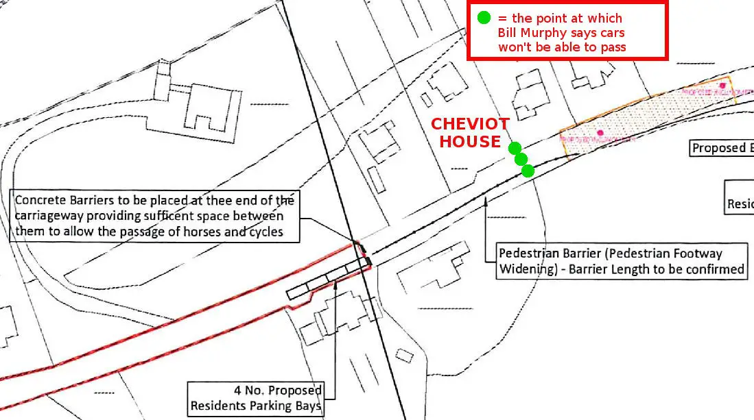
In his letter to residents, Mr Murphy (previously head of planning) goes on to say, “Due to the eastern landslip in front of Woodlands it will not be possible for vehicles to drive beyond Cheviot House”.
However this is at odds with the plans (also shared with residents), which clearly show that concrete barriers will be placed at least two properties to the west of Cheviot House (Cottage) to stop cars passing through. Also meaning there would be no vehicle access to all four properties within the concrete barriers.
Click on image to see larger version
This contradiction also appears in the recently issued council press release. OnTheWight has raised it with them and are awaiting their explanation.
Update 21.5.15
Peter Marsden, principle coastal engineer, told OnTheWight,
“The plan that was issued to residents and media is largely indicative, and as indicated in the letter to residents, surveyors will visit the site in the coming weeks to take detailed measurements which will be used to produce final plans. We felt it was important to share the initial plans with residents prior to the surveyors taking measurements on site.
“The exact point where vehicles are prevented from driving further east will be subject to site constraints, though we very much hope to get vehicular access to Mount Lavinia, Rondenbosch and Cheviot Cottage – as mentioned in the press release. However, it is unlikely that vehicular access will be possible for Fleet House and Woodlands.”
A number of other inconsistencies have been pointed out.
Resident: “Amateur drawings”
Gary Smedmore, owner of the Undercliff Glen caravan park told OnTheWight the plans had been shown to him in August 2014, so was confused as to why it has taken so long for them to be officially released.
He said,
“Island Roads have now taken 13 months to come up with these amateur drawings.
“In my view, Bill Murphy obviously cannot read plans, as his letter and plans do not match and he’s not even spotted the errors!”
One of the council’s own officers confirmed to a resident that, “The plan that was issued is largely indicative, and cannot be used for pricing.”
Residents under huge amount of stress
Barbara Wright, whose family have had to move several times since being evacuated from their property in February 2014, shared her response to the plans,
“The scheme, as it stands, is still in its infancy. Our major concern is safety. If this scheme is a temporary fix with limited stabilising plans, the Council will put us at great risk of having to move out again if it fails, under worse conditions than those we faced in 2014.
“The last scheme failed miserably, so we would like to know what is proposed in this scheme which guarantees the residents’ safety.
“Why is money being spent on a “low cost, limited access” scheme, that is not sustainable, for the benefit of so few? It will not help the local businesses.”
No contact from council in six months
Mrs Wright went on to say,
“We are all still stressed. We had a meeting with Cllr. Bacon on 7th April, which we requested, to find out how long we needed to extend our lease.
“We said to him that we hadn’t had any contact from the Council since November 2014, no consultation about proposals, which was promised at the November Executive Council Meeting 2014 and we are still waiting, both for the consultation and answers to questions we asked five weeks ago when we met Cllr Bacon.”
Other inconsistencies
A number of other inconsistencies have been pointed out by residents, such as,
- The Western turning point is stated on the plans as being for larger vehicles to turn safely, but it’s the inside of the concrete barriers which plans say only smaller vehicles can pass through – where will larger vehicles turn if they can’t get through first set of barriers?
- Plans show complete double carriageway reinstated at the caravan site: This is at odds with Ramboll’s report on the section of road patched up by residents
- The plans state vehicular access for residents and the provision of small load deliveries. The road will have width restrictions to stop fire engines, ambulances, fuel and gas deliveries, dustcarts, cesspit, road sweepers and gritting lorries
- Also the turning area east of the site is planned to be constructed over the edge of the carriageway, which has a 45 degree drop – someone with a lot of experience in this area, says the engineering involved with constructing this will be significant
The letter
Below is the letter sent to residents. You can also view the plans by downloading the PDF (right click to Save).